
A High and Lonesome Country Road Trip In the Pacific Northwest.
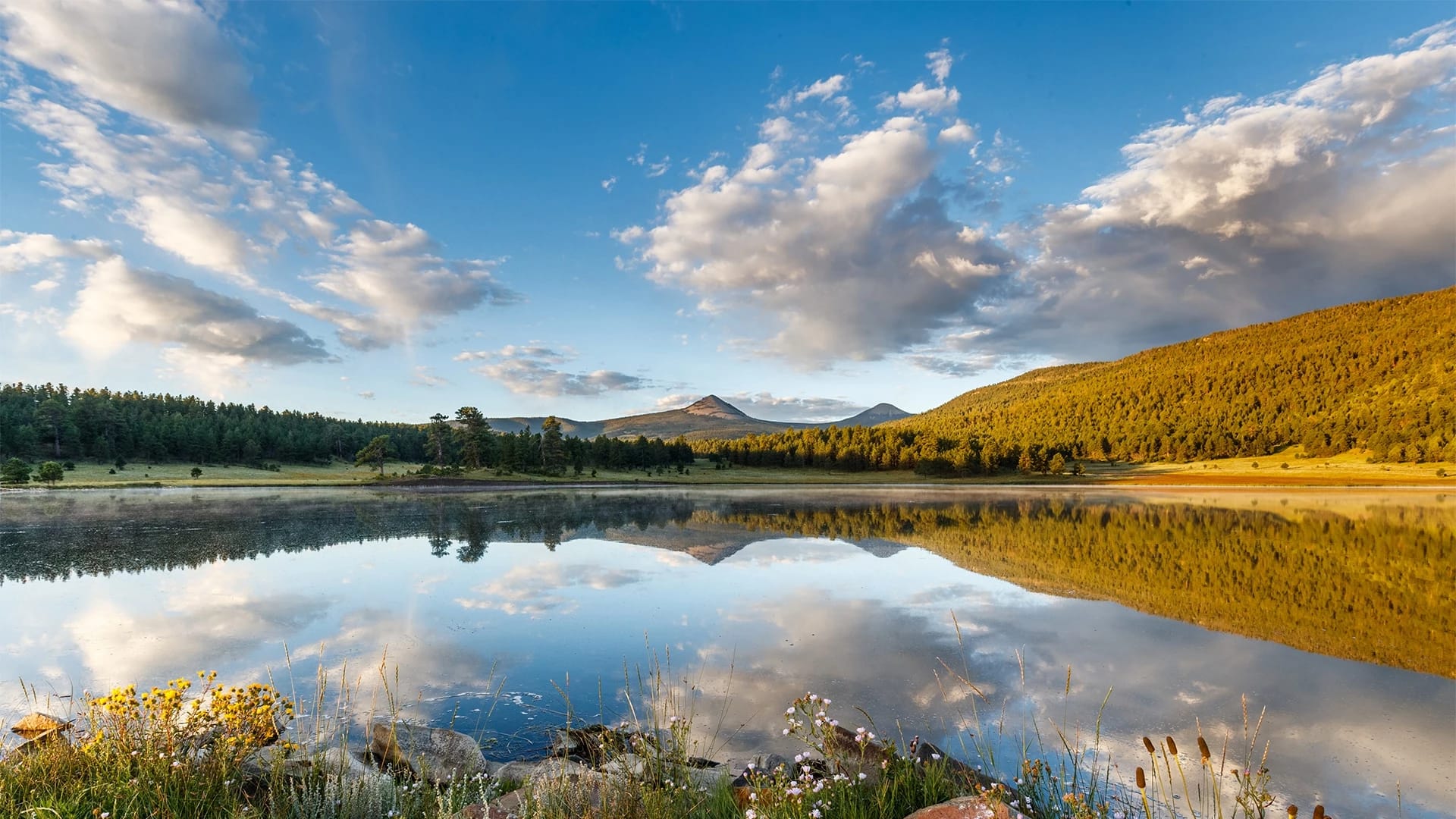
A few miles east of Baker City, a valley unzips to reveal a broad expanse of sage and wild rye. I park at a gravel pullout and drop a GPS pin. I am alone. The vastness of the Keating Valley in northeast Oregon weighs on the senses, but the lazy backs of the Virtue Hills, curling to the south, and the ragged Elkhorn Ridge of the Blue Mountains, guarding the west, keep me oriented. Even so, I’ve learned the hard way that knowing north in the desert doesn’t mean I can find where I’ve parked.
My truck disappears behind a rising tide of scrublands as I hike along a hardpan trail. It’s a brittle, cloudlesas afternoon, the high-country air sharp and scented. I walk briskly, the crunch of mudstone keeping time. Soon the trail fans out, becoming two trails, then three, each fainter than the last and slightly cupped at the edges. These are scars left by so many horse hooves, wagon wheels and pioneer feet more than a century ago. Of the 2,170 miles that the Oregon Trail covered, fewer than 300 miles of tracks remain. This spot is one of the best in the country to see them, thanks to the poor soil, compacted to a lifeless concrete.
I’ve lived in Oregon for 20 years, and I love this rural part of the state, so different from what everyone thinks the Northwest should be. Out here, a good 300 miles east of Portland, you can hike through dry canyons and moody forests and up into peaks so toothy and awesome they’re often compared to the Alps. Rivers run frothy and cool and host bull trout, Chinook salmon and famously wily steelhead, the “fish of a thousand casts.” The Blue Mountains, which top out above 9,000 feet and cover a whopping 15,000 square miles, are home to the world’s largest life form, a “humongous fungus” that spans 2,385 acres and weighs as much as 35,000 tons. Fewer than 20,000 of Oregon’s 4.3 million residents live across the three counties that make up this corner, where Oregon, Idaho and Washington converge.

I’ve driven by this pullout, the Oregon Trail Ruts Access, several times on my way to backpack the Eagle Cap Wilderness, the state’s largest wilderness area, but I’ve never bothered to stop. This time, I’m on a four-day road trip along scenic byways that will take me to these overlooked icons on the map.
I followed the Elkhorn Drive Scenic Byway on my way up from my home in Bend, passing the point where it meets the Blue Mountain Scenic Byway, coming down from the Columbia River Gorge. But I’m here for the Hells Canyon Scenic Byway, which forms a 150-mile crescent between Baker City and the artsy community of Joseph, at the foot of the Wallowa Mountains, one of several subranges of the Blues. Eyeballing those routes is about as much planning as I’ve done. I want room to wander into taverns and galleries and talk to locals, but mostly, I want to be outside. My rig, a 2016 F-150, is kitted out for adventure, with a Thule rooftop tent over the bed and a portable fire pit, water cans and a two-burner Camp Chef stashed neatly inside it, right next to a pair of fly rods.
If all goes well, maybe I’ll do something else entirely new and catch a steelhead too.
Stars are seeping into the sky by the time I make it back to the truck. I hiked about 3 miles along the ruts, past a few replica wagons splintering in the elements. I found a granite marker placed by Ezra Meeker, a pioneer who made the journey in an ox-drawn wagon in 1852, then returned to commemorate it a half-century later. Some of the earliest settlers talk of navigating their way along this section of the Oregon Trail thanks to a lone pine tree— l’arbre seul, as French traders first called it—standing like a beacon in the Baker Valley below. By 1843, though, a settler had felled it for himself.
I roll into Baker City, along streets wide enough to turn a team of horses, and get a room at the Geiser Grand, a four- story Victorian hotel with a clock tower. Many of Oregon’s towns were built on timber, but not Baker City. When it was founded, in the 1860s, gold ruled, and the riches from nearby strikes were abundant enough that settlers who’d already completed the Oregon Trail started following it again, this time in reverse, heading east to get a piece of the pie. In 1900, the son of a wealthy Swiss mining family, Albert Geiser, bought the hotel, built 11 years earlier, and renamed it. Inside, a grand mahogany staircase rises over a formal dining area with olive-green carpet and sparkling Italian chandeliers. Light pours in through the atrium ceiling, an enormous flat rectangle of translucent stained glass.


The next morning, I walk around downtown, essentially all of which is on the National Register of Historic Places. Unlike better-known Oregon towns that have embraced their status as 21st-century recreation getaways—think Bend or Hood River—Baker City has an authentic 19th-century feel, with one of the West’s largest intact historic commercial districts. Blocks of grand stone buildings with lintel corbels and boxy facades recall the days when the city was larger than Spokane or Boise. I find a store that specializes in vintage Coleman stove repairs and another that does leatherwork. Down the road are a bookstore with a display of banned books and a gallery with 100 oil paintings for sale.
Road Intel
BLUE MOUNTAIN SCENIC BYWAY
OVERLOOK: Potamus Point, for bighorn sheep sightings along the rim of the North Fork John Day River canyon.
LUNCH STOP: The Thicket in Ukiah, for burgers made with beef raised on the owner's ranch, down the road.
CAMPGROUND: North Fork John Day Campground, with 20 sites, room for large rigs, and a Wild and Scenic salmon stream running through.
PRO TIP: You'll find no services on the 90-mile stretch of Forest Service roads between Heppner and Granite.
Baker’s population recently broke 10,000 for the first time, and the city is slowly adding more New West amenities. Copper Belt Winery grows grapes on the same land that founder Travis Cook’s relatives homesteaded after coming west on the Oregon Trail in 1894. Glacier45 Distillery (where I nab a bottle of cinnamon-infused vodka, to spike my campfire cocoa) is a high-proof complement to Barley Brown’s, a storied brewpub anchoring downtown since 1998. Churchill School, built in 1926, is now an arts center with an all-ages concert venue and a hostel for cyclists and skiers who come to hit the slopes at nearby Anthony Lakes Mountain Resort.
Before leaving town, I stop by Sweet Wife bakery and cafe for a piece of chocolate babka and a chat with local journalist Lisa Britton, who has lived most of her life in Baker. “This town is so much more than I thought growing up,” she tells me. “So many people have these other lives.” She motions to a woman standing in the back. “Like her.”
The woman—tall and smiling, with a buoyant vibe—is bakery owner Jenny Mowe. She’s a former professional basketball player, drafted in 2001 by the WNBA’s Portland Fire. At 46, she’s not lost her rapid reflexes, at least when it comes to being witty. “My husband thinks it’s hysterical that I called this place Sweet Wife,” she says. “I’m so not that.” She launches into an improv performance of an argument over who should make dinner.
After basketball, Mowe followed her Baker-reared husband to his hometown, where she started selling cheesecakes and scones at the farmers market. People literally fought over them. In 2021, she opened her current shop downtown, “on the brothel side of the street,” in an 1890 building that most recently housed a seedy dive bar. It was the kind of place that held K-Y wrestling contests. “Fifty dollar prizes every round!” Mowe says. “I thought we could elevate that experience and start buttercream wrestling.”
But Old Baker remains in evidence. An antique, saloon-style backbar, columned and ornately carved, lines one side of Sweet Wife. The wood floors are original, as is an exposed-brick wall. In back stands a hand-powered elevator once used to raise and lower goods into and out of a basement with Prohibition-era tunnels. Carved into an old wooden bar, now used as a bench, are a pair of initials supposedly put there by Clint Eastwood and Lee Marvin, in the area in 1969 to film the Western flop Paint Your Wagon.
“People still come in asking to see that,” Mowe says. I ask for another piece of babka to go, then hit the road.
I’m leaving the Elkhorn Drive Scenic Byway at Baker City, but I make a note to follow more of its 106-mile circular route next time. For one, it brushes up against the North Fork John Day Wilderness, the pristine headwaters of a steelhead fishery, as well as the 23-mile-long Elkhorn Crest National Recreation Trail, the highest trail in the Blue Mountains. For now, I head east and pick up the Hells Canyon Scenic Byway, which takes me to the ranching hamlet of Halfway, population 350 or so. Its moment in the sun came in 1999, when it briefly changed its name to Half.com, a now-defunct Amazon-like online retailer. Today there’s a quirky-cool artists’ co-op called Halfway Whimsical, a tidy Queen Anne-ish Presbyterian church and a Saturday farmers market in summer.
The byway heads east for about 10 miles, skirting farmland and the green banks of Pine Creek, until the road splits. Veer left and you’ll climb up the Wallowa Mountain Loop Road, a spectacular serpentine section of pavement that rises and swoops through a dramatic country of tumbling ravines and ponderosa forests. Dozens of woodland campsites dot the route, all sitting along one creek or another in the shade. At Indian Crossing Campground, you can hike a few miles back to a swimming hole plucked out of a fairy-tale book, casting for aggressive bull trout along the way. At the Hells Canyon Scenic Overlook, you can get the long view into the screaming peaks of Idaho’s Seven Devils Mountains. Wild huckleberries grow along the shoulders.


But I’ve stayed left before. With daylight waning and temps dropping, I veer right, dropping 500 vertical feet over 7 miles into Hell’s Canyon and along the dark water of the Snake River. The dun-color walls of McLain Gulch squeeze and open around me. I cross from Pacific into Mountain Time and stop for a $2 pump-pot coffee at Scotty’s Hells Canyon Outdoor Supply. A weather-worked marquee rises out of the gravel lot next door:
IF WE AIN’T GO TIT YOU DON’T NE EDIT
Road Intel
ELKHORN DRIVE SCENIC BYWAY
PARK: Sumpter Valley Dredge State Heritage Area, where the namesake excavator, defunct 70 years, dug up a fortune in gold in its day.
PICNIC SPOT: Along the Powder River Interpretive Trail, a flat, partially paved loop of 1.2 miles along an osprey-visited stream.
CAMPGROUNDS: A-Frame RV Park in Baker City has 60-plus shady sites with hookups, all down the road from the National Historic Oregon Trail Interpretive Center. Anthony Lake Campground has no hookups, but it's next to a crystal lake at 7,000 feet with mountain views for days.
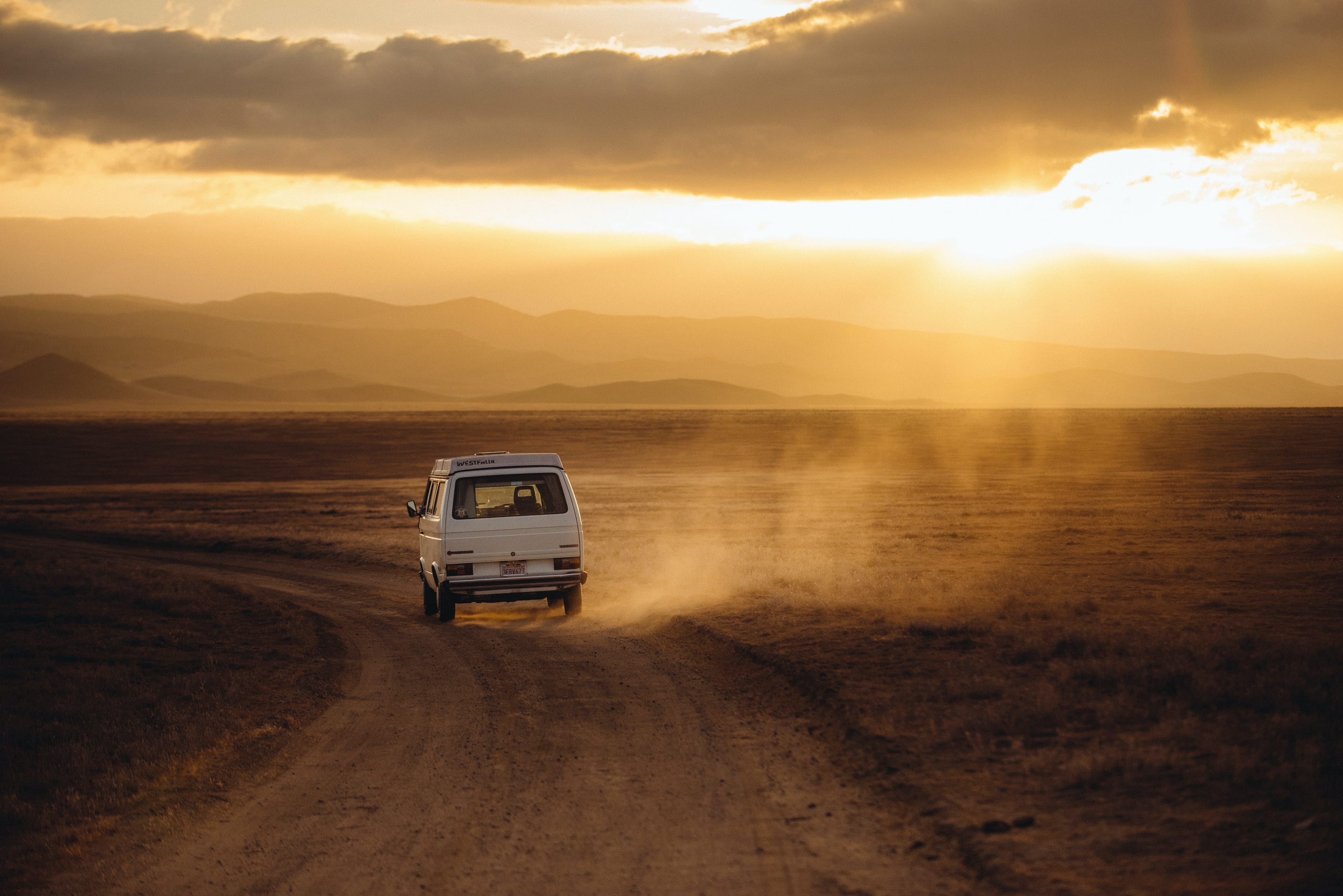
A few houses, a post office and campground sit at the bottom of the canyon, along the river in Oxbow, an unincorporated community that popped up in the early 1960s when Idaho Power built a dam. Most people who come this way cross the Snake for the paved road on the Idaho side, but I stick to Oregon, leaving the asphalt for a gravel road north. A boy with a fishing rod walks along it, next to a dog shivering with nerves. Fish roll in the current.
“Any luck?” I ask.
“A few,” he says.
We talk briefly about lures, then I drive on, through a tunnel blasted into the rock and past houses with short paved sections of road out front—like Morse code dots among the long dashes of dust. About 9 miles from Oxbow, I find home: a supremely pleasing riverside meadow with a pit toilet and two, maybe three campsites sheltered by walnut trees. A spit of earth juts out into the river, while a trail punches north into the McGraw Creek Wilderness Study Area. I back my rig down to the river, open up the tent and string LED lanterns among trees flush with oyster mushrooms. Soon I’m sitting by the fire and listening to the fish feast on bugs.
This is fat, as my dad would say. Fat, fat, fat.
Morning cracks clear and still, and I think I’ve overslept until I remember I’ve changed time zones. A hunter in a long-bed Dodge pulls into the site next to mine, trailering his horses. We chat. He has a camp set up among the scratchy hills, about 6 miles in, just beyond a distant ridge, and needs to ferry in another load of supplies. I take a short hike and sip coffee on a promontory, mesmerized by the quicksilver water. A red-winged blackbird twitters about.
I clamshell the tent, pack up the lanterns and the fire pit and roll back to the junction with the Wallowa Mountain Loop Road. This time I follow it. It takes me up nearly 3,000 vertical feet, through strobing sunlight and deep into the green heart of the Wallowas, before shooting me along a woodsy parkland along the Imnaha River.

My plan was to poke along this river, then grab dinner in Joseph, a picturesque town on the north side of the Wallowas about an hour’s drive away. But I’m having second thoughts. The camping is so great and this country so inviting, I leave the road leading to Joseph and instead turn onto a dirt road that follows the Imnaha. I spend the day looking for trout and dozing in a hammock I string up between firs. I read. Eventually I pull into Imnaha proper, a community tucked in a valley parallel to Hells Canyon. There’s not much here. A post office. What looks like a roadhouse. And the main attraction, the Imnaha Store and Tavern, a 120-year-old watering hole with weathered wood siding and single-pane windows. It’s one of the oldest continually running businesses in Wallowa County. “Hot beer, lousy food, bad service,” reads a sign out front. “Welcome.”
The place is humming inside. A dozen locals drink beer out of Mason jars and discuss the rattlesnakes frequenting the culverts. A massive woodstove crackles. A zoo’s worth of beheaded, antlered ungulates stare from the walls. It’s taco night.
Road Trip
HELLS CANYON SCENIC BYWAY
OVERLOOK: Hells Canyon Overlook, a dizzying peek into the continent's deepest canyon.
LUNCH STOP: Hells Canyon Inn near Oxbow, for sand- wiches, beers and billiards.
DAY HIKE: Wallowa Tramway Summit Trails in Joseph, 21⁄2 miles of alpine splendor at the end of a 3,700-foot gondola ride.
CAMPGROUNDS: Mountain View RV Park in Joseph, which lives up to the name. Wallowa Lake State Park, with 121 full-hookup sites, boat rentals, disc golf, a swimming hole and more.
Soon I’m chatting with proprietor Cody Mawhinney, who has an ink-black beard and forearms made of truck pistons. Mawhinney grew up in Baker City, worked for the state roads department and bought the tavern in 2019.
“You the truck with the fly rods?” he asks.
“Yeah, but I’m not finding much.”
“I’ll tell you where to go.”
He loads me up with a few pieces of walnut firewood for the night and points me down Lower Imnaha Road. The pavement ends after about 6 miles, and suddenly I’m on what must surely be the most spectacular road in all of Oregon.
Up and up I go, the river below squeezed into a metallic trickle, pinched between pale green canyons freckled with basalt. The road rears back to more than 10 degrees, and the hairpin turns have me white-knuckling the wheel. The route is etched into the steep canyon wall like a contour line on a topographic map. A flock of wild turkeys flees before my creeping bumper. There’s a bighorn ram across the way.
The road ends at a place called Cow Creek, some 20 miles north of Imnaha, where I set up camp on a flat spot near the river’s edge, over a gravel bar. On the far side of the river, across a bridge, stands a white canvas tent, part of a fish-tagging station run by the Nez Perce Tribe, which co-manages watershed resources in the Snake River Basin. A screw trap whines in the current.
The next morning, Joe McCormack, a Nez Perce tribal member, lets me hang out with him as he collects buckets of steelhead and Chinook smolts from the trap, sedates them, weighs and measures them and pops a rice-size RFID tracker into their belly fat, so receivers from here to the Pacific can pick up whenever the fish pass close. These are his tribe’s ancestral winter grounds, and the Nez Perce have relied on fish runs in this watershed for thousands of years. He’s been tagging in this spot for 30, part of an effort to monitor and recover sea-run fish numbers decimated by overfishing, pollution and, particularly, dams. I watch as his leathery hands hold these delicate miracles like they’re skeins of ancient silk. “Lot less of ’em than there used to be,” he says. “I think people are starting to listen, though.”
Come afternoon, I’ll pack up and head into Joseph, where kids wander with ice cream cones and fire pits crackle outside Embers, a pub with pizza. Joseph, population 1,150, was Oregon’s first town to declare itself an “arts and cultural district,” on account of its bronze foundry, plentiful public sculptures and numerous studios and galleries. It’s a great place to rest after backpacking trips and to splurge on a decadent meal at the Wallowa Lake Lodge, a 22-room chalet built in 1923 and now owned by more than 100 Pacific Northwest families who rallied to save it from disrepair.


For now, though, I’m here with McCormack, whose work is done for the day. He packs up and tells me to hike with my rod downstream. “The fish are in there,” he says. It’s about 6 miles to the confluence with the Snake, but I don’t go that far. Instead, I sit on a rock and watch the water flow over ledges and into a black pool with a tongue of current spitting bubbles along the eddies. I’ve been to Mongolia, Antarctica and deep bush Alaska. Something about this feels just as remote.
I scramble down a small cliff and pay out some line. This is the best part of fishing— and of road trips and a rig that can take you to places like this. I roll-cast 20 feet out and watch as the fly swings languidly through the tailwater. In a flash of brilliant chrome, the river explodes, and my line goes tight.
Read more like this